Open pit mining – Loosening zones along a transportation route
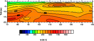
Cavities and loosening zones have to be detected on a marked-out route for the transportation of a heavy bucket wheel excavator to another open pit. Beside gravity measurements a seismic refraction survey with small source and receiver spacings was carried out. With a tomographic travel time inversion of first breaks the p-wave velocity field of the underground was determined and indications for loosening zones and consolidated areas were found.
For research pursues only this dataset is available upon request. Please contact andreas schuck ∂does-not-exist.ggl-gmbh de.
- Raw seismic data: SEG-2
- Geometry, observer logs, coordinates: Excel table
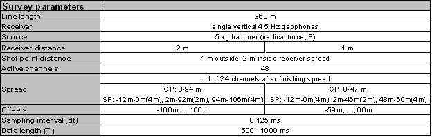
Table with survey parameters
Raw data example with receiver distance of 1 m and TAR applied

Detail of the velocity field which results from the tomographic travel time inversion